NOTE: NewsPlus will plan on posting two updates an AM and PM update to our website and more if needed. Please follow our Facebook page for any timely updates throughout the day.
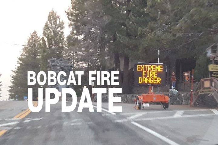
SEPTEMBER 21, 2020 – BOBCAT FIRE Evening UPDATE 10:00 PM: The Bobcat fire has now burned 106,179 acres, burning almost 900 acres today and is now only at 13% containment. There is 1,513 personnel on the fire, 227 engines, 25 hand crews, 6 helicopters, 18 dozers, 11 water tenders, and numerous aircraft working on this fire. The fire perimeter is 219 miles long and so far crews have dozed 71 miles of line and 15 miles of hand-cut line.
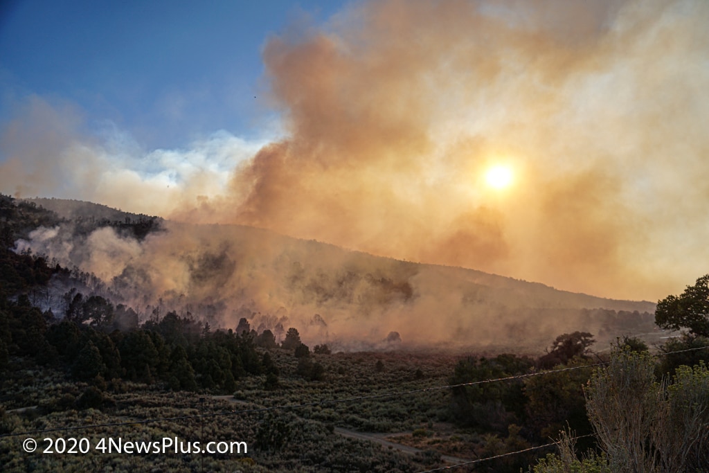
The fire was active today, large amounts of smoke could be seen over the desert for most of the day. Air Quality was poor. In the Tri-Community, for most of the day, winds were blowing to the west, keeping smoke from the Bobcat fire away; however, you could see a haze most likely from the El Dorado Fire.
While on the El Dorado fire subject, the San Bernardino National Forest announced today the loss of Big Bear Interagency Hotshot, Charles Morton, who died while engaged in fire suppression operations on the El Dorado Fire. You can read the article HERE.
The day started off as usual with spot planes surveying the fire planning the day’s airdrop missions. Winds started to pick up and the started to get active. Planes began making runs but were briefly shut down when a drone or weather balloon was spotted over the south end of the fire. There still has been no clarification on what exactly it was that caused the issue. Fire activity has been persistent with the most activity around Mt. Wilson, Chilao, and Little Rock Creek. While I’ve been focusing on the north-eastern side of the fire, the eastern flank of the fire, east of Mt. Islip has been creeping east across Highway 30 and along Highway 2 heading toward Dawson Saddle just to the south of Mt. Lewis. Directly north of Dawson Saddle on the north side of Mt. Lewis is Big Rock Creek, Pinyon Ridge, and Mile High (Largo Vista Rd.). See the map below. The fire was also active in the Antelope Valley with fire burning south of the Littlerock Reservoir
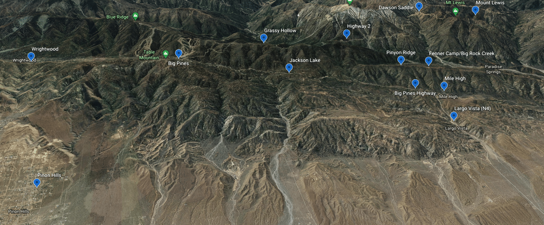
Crews were working on Pinyon Ridge all day cutting containment lines for burning operations to fill in the “fingers” of the fire creeping down toward Big Rock Creek and Camp Fenner. As the day progressed firing operations halted because of wind, fire started pushing down from Mt. Lewis, and the Pinyon Ridge area started to become active. Dozers were busy cutting indirect lines to stop any easterly movement of the fire in that area.
In the Mt. Wilson area, the fire is burning in the Highway 2/Highway 39 area. This and the fire burning on the Antelope Valley side of the fire, and the fire/ burning operations on Pinyon Ridge were producing all of the smoke we were seeing today. At about 9:00 pm residents on the desert foor started reporting seeing flames coming from the Largo Vista/Mile High area of the fire. Most likely they are seeing flames from Pinyon Ridge and more likely Mt. Lewis (This is speculation on my part.).
As of 11:00 pm the fire has reached Dawson Saddle and fire is spotting. Crews are there putting out spot fires and trying to hold the line. They have also been doing some “torching” closer to Highway 39 and Highway 2.
The Angeles National Forest held a community meeting this evening at 6:30 pm on their Youtube channel. A lot of good information was given, but the audio was very poor, let’s hope they fix that for then next community meeting scheduled for the end of the week. San Bernardino County Fire reported that they are continuing to monitor the fire activity. They have contingency plans in place for evacuation and structure defense for the Wrightwood, Pinon Hills, and Phelan areas should the fire move into San Bernardino County. San Bernardino County Sheriff’s has assigned two extra patrols to the Wrightwood area. All San Bernardino County residents are encouraged to sign up for the TENS alert system to get notifications via phone/text or to download the Ready SB App.
Planned actions for tomorrow according to Incident Command are to “Continue direct and indirect line construction with resources available utilizing pre-existing dozer lines when possible. Provide structure protection when fire impacts communities.”
According to Incident Command, the projected fire activity is as follows “The Bobcat Fire has impacted SR 2 again and is threatening inholdings and infrastructure
including 500 Kv lines on the west side of the fire. The fire will continue to burn actively overnight with less moderation on the higher elevations of the fire. On the east side, the fire continues to threaten containment lines north of the Ranch 2 fire and threatens the SR39 corridor. Fire east and north of Mt Wilson will continue to flank and threaten the values on Mt. Wilson.”
Evacuation Orders:
- South and West of Upper Big Tujunga.
- East of Angeles Forest Hwy.
- North of Angeles Crest Hwy.
- Residences along Angeles Crest Highway, between Angeles Forest Highway and Highway 39.
- The unincorporated areas of Juniper Hills, Devils Punch Bowl, and Paradise Springs.
- The unincorporated areas of Crystal Lake, East Fork of the San Gabriel River, and Camp Williams.
- South of Hwy 138, North of Big Rock Creek, East of 87th St East, and West of Largo Vista Rd.
- South of 138th St. East, North of Big Pine Hwy and Hwy 2, East of Largo Vista Rd., and West of 263rd St. East.
- South of Hwy 138, North of East Ave W-14, East of 155th St East, and West of 165th St. East.
Evacuation Warnings:
- City of Pasadena
- Unincorporated communities of Altadena, Pinon Hills and Wrightwood.
- South of Pearblossom Hwy, East and North of Angeles Forest Hwy, North and West of Mt. Emma Rd., East and South of Hwy 122, and West of Cheseboro Rd.
- South of Hwy 2, North of Blue Ridge Truck Trail, East of Hwy 39, and West of the Los Angeles Co. border.
- South of Ave U-8, North of East Ave W-14, East of 121st East, and West of 155th St East. (Longview)
- South of Pearblossom Hwy (Hwy 138), South and East of Pearblossom Hwy (Hwy 122), North and West of Mt. Emma Rd., North and East of Angeles Forest Hwy, and West of Cheseboro Rd. (Emma)
- South of Mt. Emma Rd., North of Upper Big Tujunga Canyon Rd., East of Angeles Forest Highway, and West of Pacifico Mountain
- Littlerock: East of Cheseboro Road, South of Pearblossom Hwy, North of Weber Ranch Rd, West of 87th St E.