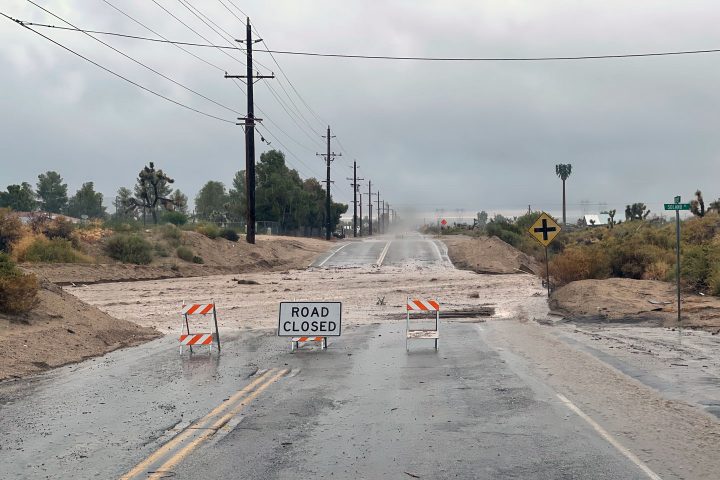
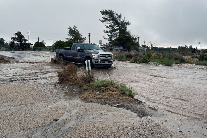
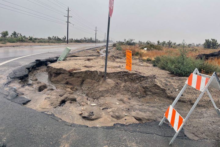
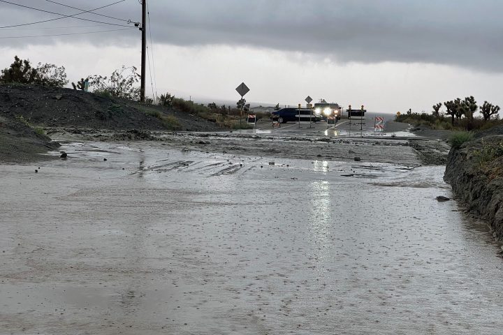
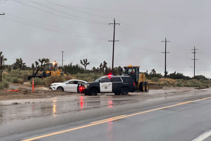
UPDATE AUGUST 20, 2023, AT 5:45 PM: Rain, Rain, Rain for Wrightwood. Highway 2 is closed at Sheep Creek Wash. Water, and debris are flowing over the bridge. Lone Pine Canyon is also closed. Thrush is closed between Victorville and Heath Creek. Many businesses are closed, and creeks and washes are flowing with lots of water and debris. See the videos below.
The rain continues to fall in Phelan. There were a few breaks around 11:00-12:00 pm. Rain has been coming down steadily since about 1:30. Almost every road in the area has been impacted in some way. Watch for debris flowing onto roadways–old tires, rocks, and assorted trash. Hwy 138 is closed at Phelan Road. Sheep Creek Road is closed at Amador (about 3.5 miles north of Phelan Road). Ducan Road is closed at the Sheep Creek Wash. The wash at Johnson Road near Fountain of Living Waters Church is flowing with debris across, as is the wash at Sheep Creek Road near Nielson Road. Phelan Road from Highway 138 to Sheep Creek is passable, but there is debris. Dirt and water across the road at Beekley and new Labec, the usual places. Phelan Road, east of Sheep Creek to Johnson Road, is flooded with debris and dirt near the elementary school. Nielson Road from Johnson to Beekly is also passable, with a few places flooding the roadway, especially west of Sheep Creek. Highway 138 from Beekley to Phelan Road is also passable, with rain runoff causing havoc on dirt roads that empty to the highway. That was the extent of my recon. Rain totals as of 5:45 pm are 6.83″ in Wrightwood, 4.84″ at the Phelan Dump, and 3.28″ at Wilson Ranch (near the aqueduct), according to SBC weather stations.
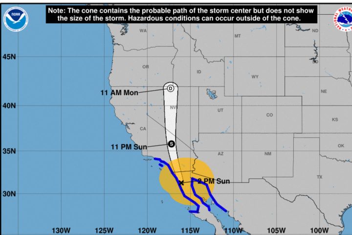
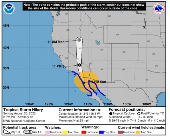
From the National Weather Service, Tropical Storm Hilary has taken a more easterly track which could bring less wind to the lower elevations. However, the mountains will be susceptible to stronger 50-60 mph gusts through tonight. The center of Hilary is still south of California. Rain rates of 1-2 inches per hour are still possible as the center of Hilary moves over the area this evening.
No School Tomorrow per Snowline Schools:
Good evening,
We hope our Snowline Community has remained safe during this Tropical Storm Event! We still have several bands of moisture heading our direction, so please stay vigilant these next several hours!
Tropical Storm Hilary has severely impacted our area, causing substantial damage to our roadways, resulting in several road closures within the Snowline boundaries.
Due to inclement weather and road closures, all Snowline Schools will be closed on Monday, 8/21/23. We will provide an update on school site operations tomorrow afternoon as the storm moves out of our area, and we can asses our facilities and roadways. If you must be on the roadways, please be safe, and remember, “Turn Around, Don’t Drown.”
Images & Videos
https://twitter.com/TransverseDream/status/1693286782555820217/video/1
UPDATE AUGUST 20, 2023, AT 9:30 AM: Phelan, Pinon Hills, and Wrightwood continue to be in the direct path of Tropical Storm Hilary. Rain began to fall in the Tri-Community around 5:30 am (at my location in Phelan) and has not stopped. It has been raining steadily, with periods of heavier rainfall. The ground is saturated, and there is water runoff. Currently, the wind is relatively calm in Phelan, with no gusts that I have noticed. Current (9:30 am) rainfall totals as recorded by SBC weather stations are 2.42″ inches reported at the Wrightwood Fire Station, 1.74″ inches reported at the Phelan Landfill, and 1.30″ inches reported at Wilson Ranch near the aqueduct.
The National Weather Service reports that as Hilary moves northward, expect winds to pick up late morning into the afternoon. There could be locally stronger winds in the mountains. Rain is expected to intensify through the morning, with the heaviest rainfall from late morning into the evening. A Tropical Storm Warning is in effect as well as a Flood Watch for the mountains and deserts of San Bernardino County. Hilary is expected to bring several inches of rain and high winds into the area as the day progresses. Please use caution and common sense if you have to go out into the storm.
A Tropical Storm Watch has been issued for much of Southern California, including the Apple and Lucerne Valleys, the San Bernardino County Mountains and Valleys, and the Inland Empire.
As Hurricane Hilary, a powerful category 4 hurricane producing windspeeds of 130 mph, approaches Southern California sometime Sunday afternoon into Monday morning, it will likely weaken to tropical storm strength producing winds from 39-73 miles per hour. According to the National Weather Service, the Tri-Community should see weather conditions deteriorate on Saturday as rain bands begin to move into the mountains and deserts of San Bernardino County by Saturday evening into Sunday. These rain bands will have the potential to produce heavy rainfall and gusty winds. Within these bands, there could be brief spin-ups and tornadoes, which tend to be short-lived but can still cause damage. By Monday afternoon and evening, Hilary is expected to weaken as it continues northward. Wind and rainfall are expected to taper off through Monday afternoon and evening. Through the end of next week, the mountains and deserts can expect chances for daily showers and storms.
A flood watch has been issued, remaining in effect from Saturday morning through Monday afternoon. Flash flooding may occur across areas with the heaviest rainfall bringing the potential of flash floods, landslides, mudslides, and debris flows over burn scars from recent wildfires. San Bernardino County Flood Control is pre-staging equipment and barricades in flood-prone areas, and staff will be monitoring flood control channels and basins. San Bernardino County Officials advise all residents to have supplies on hand to protect and sustain their families and homes.
“Sandbags are available at our fire stations,” said San Bernardino County Fire Chief Dan Munsey. “I strongly encourage our residents to prepare their properties for this storm. Our fire district is working closely with the San Bernardino County Sheriff’s Department, as well as the San Bernardino County Office of Emergency Services, to ensure our county is prepared for flood and debris flow.” According to the SBC Fire website (sbcfire.org/sandbags), Tri-Community residents can pick up sandbags in advance of the storm at Station 10, located at 9625 Beekley Road in Phelan, Station 13 located at 10433 Mountain Road in Pinon Hills, and Station 14 located at 5980 Elm Street in Wrightwood. Additionally, the San Bernardino County Sheriff’s Department urges everyone to take precautions while on the road and avoid driving through flooded streets.
Chances of rain are expected to increase beginning Saturday morning. Precipitation associated with tropical storms occurs in bands, making it likely to be off-and-on through most of this storm. The heaviest rainfall will most likely happen Sunday night through Monday morning. The National Weather Service is forecasting 2.5 – 4 inches could fall in the Inland Empire, 3-7 inches in the deserts, and 6-10 inches in the mountains, with local amounts up to 12 inches. However, the heaviest rainfall is expected to occur along the east-facing slopes of the desert, where rain rates could reach 3 inches per hour. Elsewhere, rain rates, possibly in short bursts, could get 1-2 inches per hour in a rain band.
Hurricane Hilary is also expected to bring high winds, with the strongest winds occurring across the mountains and near the center of Hilary as it tracks across the area. Tropical storm-force winds of 39-73 miles per hour are possible throughout the warning area. Isolated tornadoes will be possible along rain bands, and the Storm Prediction Center has marked Southern California as a Marginal Risk for severe thunderstorms and wind gusts. High winds from Hilary could knock down powerlines and trees, especially if the soil is saturated.
While tropical systems have impacted Southern California before, this is the first time a Tropical Storm Watch has been issued by the National Hurricane Center/the National Weather Service in Southern California.